OpenOrienteering is a project developing a collection of tools which help with the creation of orienteering maps and the organization of orienteering events.
Posted on 01 October 2012 by Kai Pastor
We are glad to release a Mac OS X package again, thanks to great support from Oskar Karlin. Bringing the Mac OS X version on par with Windows and Ubuntu took a number of changes to the code and to the build system, collected in release 0.3.2.
Mac OS X users and new users shall use the new Mapper release 0.3.2.
For users of Mapper release 0.3.1, there is no need to upgrade to 0.3.2.
Note that we still have no permanent package maintainer for Mac OS X, i.e. someone who will do the next release packages.
Downloads
Mac OS X package (64-bit) (17.3 MB)
Windows installer (13.8 MB)
Windows ZIP archive (17.7 MB)
Ubuntu 12.04 package 32-bit (i386) (1.6 MB)
Ubuntu 12.04 package 64-bit (amd64) (1.6 MB)
You can always find the latest binary and source release on http://sourceforge.net/projects/oorienteering/files/Mapper/
Contributing
If you want to work on a translation for Mapper, are a programmer with experience in C++ / Qt, or want to help in any other way, we would like to welcome you at our developer mailing list. Other useful places with resources are:
Git repository with the latest code
Bug tracker, the right place to lookup and report all kinds of issues with the program
Developer wiki with information about the code, or how to start a new translation
Posted on 26 August 2012 by Kai Pastor
We are glad to announce an updated alpha version, OpenOrienteering Mapper release 0.3.1.
Downloads
Windows installer (13.8 MB)
Windows ZIP archive (17.7 MB)
Ubuntu 12.04 package 32-bit (i386) (1.6 MB)
Ubuntu 12.04 package 64-bit (amd64) (1.6 MB)
You can always find the latest binary and source release on http://sourceforge.net/projects/oorienteering/files/Mapper/
Release Notes
This a snapshot release intended for review and testing. It is not recommended for productive use unless you know what you are doing. We are looking forward to your feedback on bugs, missing features or annoyances.
In addition to bugfixes, this release contains improvements over 0.3.0 especially for Windows users:
Windows installer (new!)
When using the Windows installer with administrator privilege, the .omap file extension will be associated with the Mapper program.
Windows packages include the Qt Assistant which is needed to view the manual.
Missing geographic projection data was added to the Windows packages.
Translation updates for Deutsch (German - de), 日本語 (Japanese - ja), Latviešu (Latvian - lv), norsk bokmål (Norwegian Bokmål - nb), svenska (Swedish - sv), українська мова (Ukrainian - uk)
Contributing
If you want to work on a translation for Mapper, are a programmer with experience in C++ / Qt, or want to help in any other way, we would like to welcome you at our developer mailing list. Other useful places with resources are:
Git repository with the latest code
Bug tracker, the right place to enter all kinds of issues with the program
Developer wiki with information about the code, or how to start a new translation
Posted on 05 July 2012 by Thomas Schöps
The OpenOrienteering team is happy to release the third alpha version 0.3.0 of its free orienteering mapping program today, containing numerous new features and improvements.
Download For Windows: openorienteering-mapper_0.3.0-win-x86.zip
For Ubuntu Linux 12.04 (Precise), 64 bit: openorienteering-mapper_0.3.0-precise_amd64.deb
For Ubuntu Linux 12.04 (Precise), 32 bit: openorienteering-mapper_0.3.0-precise_i386.deb
To view the integrated manual, the help file viewer “Qt Assistant” is required in addition. For Linux it should be installed by the package manager, for Windows it is provided as a separate download because of the file size. To download it (or the program sources), go to the SourceForge downloads directory.
Highlights Apart from many minor improvements, we would like to point out the following changes:
Templates, data import and export
Exporting maps in OCD 8 format
Loading OpenOrienteering and OCD 8 maps as templates
Exchange of data between map files
Loading GPX, DXF and OSM files as templates, and importing them into maps
Symbol sets
New ISSOM symbol sets (1:4000, 1:5000)
Improved symbol documentation
Editing tools
Circle/Ellipse and rectangle drawing tools
Length and area measure tool
Area union, intersection, subtraction and xor tools
Scaling tool
User interface
Many dialogs redesigned and simplified, Help and Reset buttons added
Input fields display units of measurement
Translations and localization
Japanese
Swedish
Ukrainian
Number formatting according to localization
Other new features
Built-in help
Program settings dialog
Much faster map drawing especially when interacting with many objects
Copy’n’Paste for symbols and map objects
Note
This is a snapshot release intended for review and testing. Although the ocd export functionality gives the possibility to continue work on maps with other programs in case this should be necessary, this version is not recommended for productive use unless you know what you are doing. We are looking forward to your feedback on bugs, missing features or annoyances.
Screenshots (Examples)
Drawing a rectangular object:
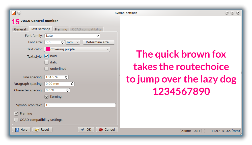
Redesigned text symbol options:
Contributing
If you want to work on a translation for Mapper, are a programmer with experience in C++ / Qt, or want to help in any other way, we would like to welcome you at our developer mailing list. Other useful places with resources are:
Git repository with the latest code
Bug tracker, the right place to enter all kinds of issues with the program
Developer wiki with information about the code, or how to start a new translation
Developers
Following is an alphabetically sorted list of all people involved in developing this version of Mapper (apologies in case anyone has been forgotten). Thanks to all who helped to make this release possible!
Peter Curtis Jan Dalheimer Eugeniy Fedirets Peter Hoban Henrik Johansson Tojo Masaya Kai Pastor Thomas Schöps
Posted on 27 March 2012 by Thomas Schöps
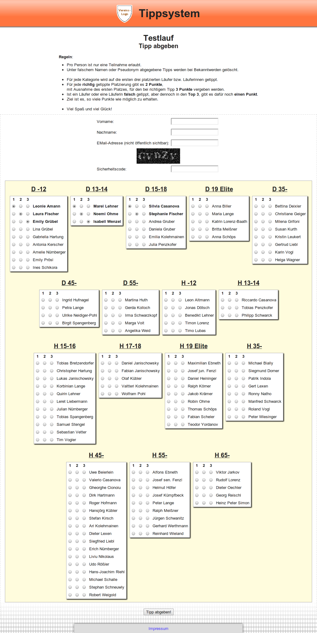
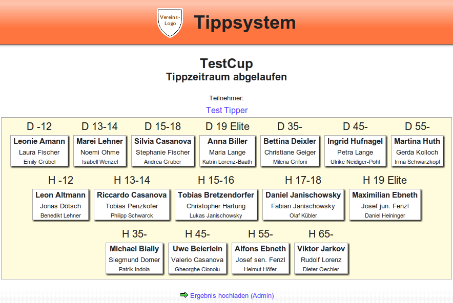
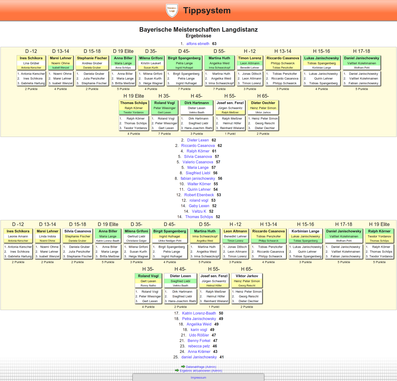
An online betting system for orienteering competitions developed by Thomas Schöps is now publicly available, after it has been successfully tested at the Bavarian Long Distance Championships. It is only available in German for now.
The web application uses PHP and MySQL. It works together with the SportSoftware programs OE2003 and OE2010, relay races are not supported. Creating a new betting contest and calculating the results is as easy as generating and uploading a CSV export file from the SportSoftware application.
Screenshots:
Posted on 24 March 2012 by Thomas Schöps
After many hours of work, the second alpha version of OpenOrienteering Mapper has been released today. Highlights of this version include:
Import of OCAD 8 files, including symbol sets
Addition of the text drawing tool
Many new editing tools
German translation
You can read the full changelog here.
Note Even though this version represents a huge improvement over the first alpha, we still do not recommend to use it for map projects because the planned OCAD export feature and some basic editing tools are still missing. As far as it can be judged now, the next version after this one could include these and be the first version which will be recommended for mapping.
Download System requirements: Windows (XP or newer), Mac OS X (compile yourself), or Linux (binary package for Ubuntu: depends on Qt 4 libraries, or compile yourself)
Binaries for Windows: Mapper-alpha2.zip Binaries for Ubuntu Linux: openorienteering-mapper_0.alpha-2.1-oneiric_amd64.deb (Ubuntu 11.10 64-bit) openorienteering-mapper_0.alpha-2.1-lucid_i386.deb (Ubuntu 10.04 32-bit) Source for all platforms: Mapper-alpha2-src.tar.gz
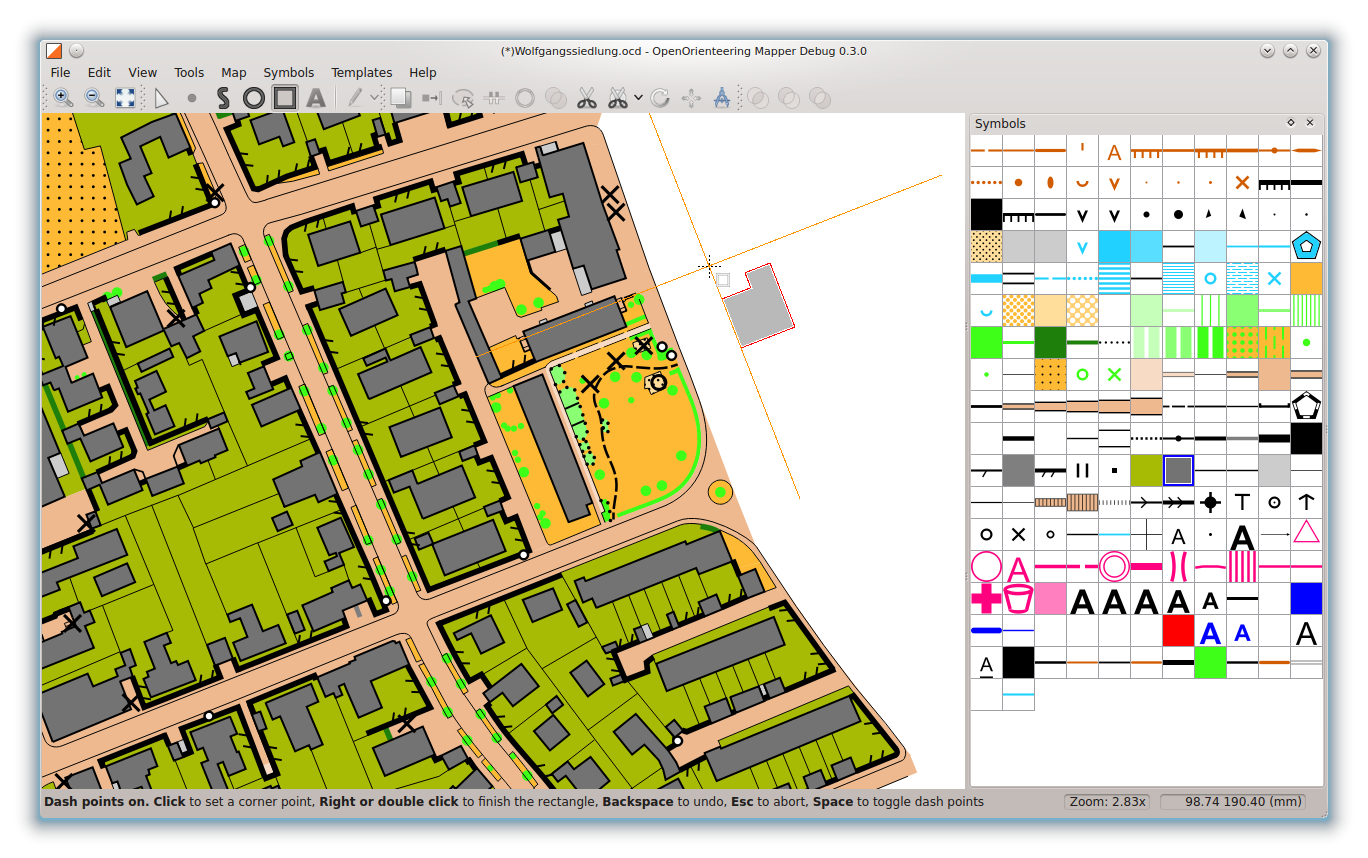
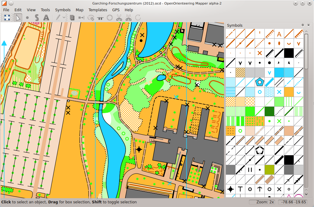
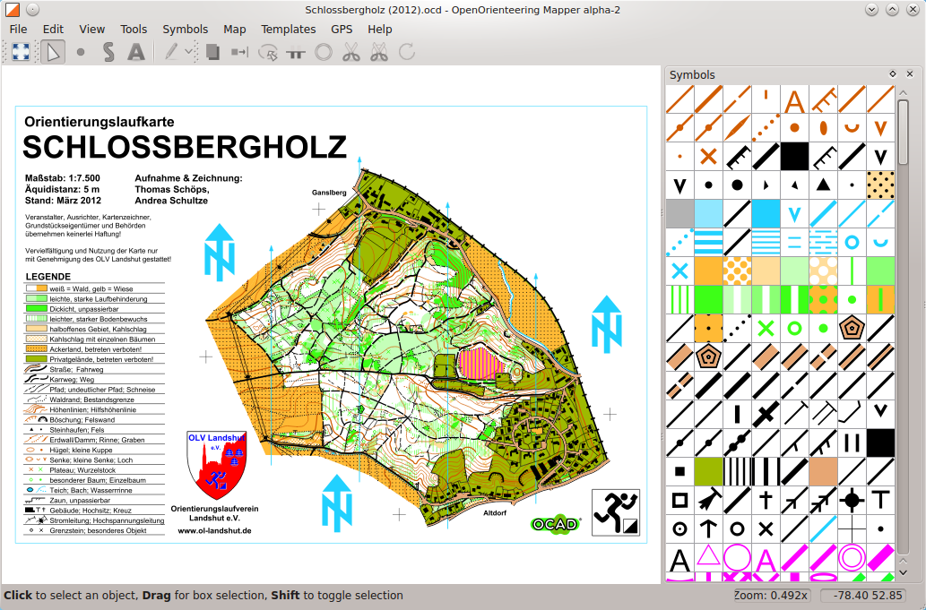
Screenshots Two OCAD maps loaded into OpenOrienteering Mapper:
Contributing There is a lot to do, and we appreciate every kind of help, whether you are a programmer or not. As an example of a programming free task, ‘official’ symbol sets for Sprint, MTB and Ski orienteering maps are still missing. If you are interested in contributing, good places to start are:
Git repository containing the latest version
Ticket system showing tasks that have to be done, and the right place to report bugs
Developer mailing list for discussions (and introducing yourself ;-) )
Developer wiki for information about the code
Developers The people who made this release possible are, as an alphabetical list of the developers registered at the SourceForge project: Peter Curtis Kai Pastor Russell Porter Thomas Schöps Of course, we would also like to thank everyone else who helped!